HunterdonMorris
Califon Borough
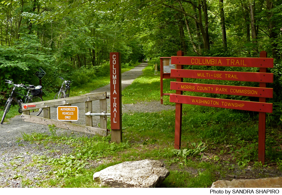
Columbia Trail
Califon Borough, NJ 07830


Last Updated: 10/27/2014
Overview of Selected Trail
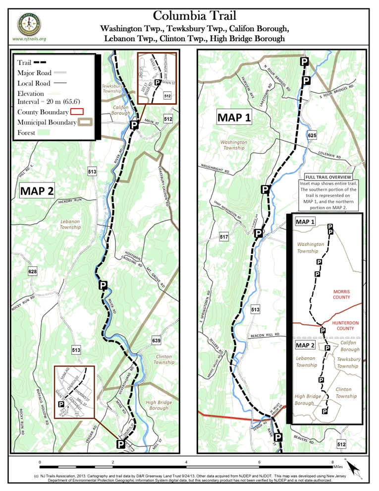
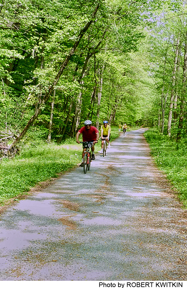
The Columbia Trail is a multi-use path that follows an abandoned railroad corridor for over 15 miles. The trail runs from the border of Mt. Olive and Washington Townships in Morris County southwest to downtown High Bridge in Hunterdon County. Each county section is managed by its respective County Park System. Named for the Columbia Gas Line that follows the railroad corridor alignment underground, the trail passes through some of the most scenic landscapes in the Highlands region. The South Branch of the Raritan River is a steady “companion” along this trail.
The trail accommodates equestrians, bicyclists, joggers, families with strollers, wheelchair hikers, and cross-country skiers. The trail surface is not paved, so activities requiring smooth, flat surfaces, such as rollerblading, are not possible. Generally the surface is hard packed natural dirt and clay, or gravel, in Morris County. In Hunterdon County, the surface is uniformly crushed stones navigable by wheeled vehicles.
-
-
Distance:
This trail is divided into two sections: Section 1 – Mt. Olive to Tewksbury, Hunterdon County (8.1 miles); Section 2: Tewsbury County to High Bridge, Hunterdon County (7 miles).
Time:
Walking the entire 15-mile trail might take five or more hours, depending on pace. See map to plan ahead and walk in sections.
Markings:
Markers indicate intersections with other trails. Brown posts mark the intersection with the “Gillette Trail,” part of the Patriots Path system, a cross-county trail managed by the Morris County Park Commission. Teal-color blazes indicate an intersection with the Highlands Trail, which connects preserved lands throughout the Highlands region.
Trail Usage:
Walking/Hiking, Dogs permitted on leash, Mountain biking
Elevation:
Relatively flat trail curves along the South Branch River, with elevation gains typical of former rail lines.
Difficulty:
Moderate
Parking:
There are eight parking areas along the 15 mile length in Hunterdon and Morris counties.
Tips:
The trail corridor is crossed by many informal footpaths and paved driveways. Before exploring any of these side trails and leaving the main corridor, trail users must pay attention to the ownership signs posted on trees along the trail. If the signs indicate “no trespassing” or “private property”, please respect the rights of private property owners and stay on the Columbia Trail.
More information about the Columbia Trail and related trails and sites can be found through the following links:
NJ Division of Fish & Wildlife, Wildlife Management Areas
Borough of High Bridge, including Lake Solitude
New York-New Jersey Trail Conference
Amenities:
In High Bridge Borough across Main Street from the trailhead is a public park called High Bridge Commons. The park has ballfields, playground, and gazebo. High Bridge is a quaint downtown area offering restaurants, pizzerias, delis, and other places for refreshment.
Directions:
To start at western (High Bridge) trailhead: From the junction of Route 78 and Route 31 in Clinton, proceed north on Route 31 for 1.7 miles to Route 513 north. Turn right and follow Route 513 into High Bridge. After approximately 1 mile, after passing under the train tracks, turn left into the center of High Bridge. To park just before the Borough Hall turn left onto Van Syckles Street to a municipal parking lot. (See trail description for each trail section for directions and parking.)
-
Section 1: Mt. Olive, Morris County to Tewskbury, Hunterdon County (8.1 miles)
This first trail section generally follows the South Branch of the Raritan River as it meanders back and forth, switching sides, along the rail corridor. The trail is scenic, flanked by hardwood and coniferous woodlands and farms. The section is shaded much of the route because of the density of the surrounding forests.
Directions to eastern (Mt. Olive) trailhead: From the north, exit I-80 at Route 206 south (exit 27). Travel on Route 206 for 3.9 miles, passing through 3 lights, and turn right just before a railroad trestle, following green signs to “Bartley.” At .6 miles from Route 206, the road curves at the intersection with River Road; stay left and do not turn on River Road. After another .4 miles, the road forks—stay to the right (still on Bartley Road). The trailhead and gravel pullout parking lot will be on the right in another .5 miles.
Traveling from Chester, Somerset County and I-287, take Route 206 north towards Flanders. Turn left at the light in Flanders on the cross street marked Flanders-Bartley Road. At the deadend, turn left on Bartlely Road, follow it past the intersection with River Road, and continue to the trail head, following the directions above.
Parking: A gravel pullout parking lot for about 3-4 cars is located at this trailhead, marked by a brown sign “South Branch of Raritan Wildlife Management Area”.
A parking lot .3 mile further west along Bartley Road from the trailhead accommodates about 10 cars and is another place to access the trail. A brown sign marked “Fishing Access” from Bartley Road indicates the drive to the parking area.
In 3.3 miles, the land to the north of the Trail is Schooley’s Mountain Park, a county park. On the Columbia Trail, a brown post marks the intersection with the “Gillette Trail.” Taking this trail north for about .1 mile leads to a parking lot and trailhead. The Gillette Trail is part of the Patriots Path system, a cross-county trail managed by the Morris County Park Commission. This section of trail is also part of the Liberty Water Gap Trail, a long-distance trail network across New Jersey linking the Delaware River in the west and Liberty State Park in the east. The teal blazes that coincide with the Columbia Trail in this section indicate an intersection with a third long distance trail, the Highlands Trail, that connects preserved lands throughout the Highlands region. When completed, the Highlands Trail, a project of the New York-New Jersey Trail Conference, will extend about 150 miles, connecting the Delaware River at Riegelsville to Storm King State Park in New York State. The teal blazes of the Highlands Trail continue along the Columbia Trail for the next 8 miles.
The trail user has a choice at this point because the railroad corridor is interrupted. (Efforts are underway to complete this interrupted trail section through Long Valley, so trail users should be alert for change.) One option, from the entrance to the parking lot at the Gillette trailhead, is to turn west (left) onto Fairview Avenue and follow it to Schooley’s Mt road in Long Valley in .8 miles. A second option is to continue along the Columbia Trail, which is interrupted by a private manufacturing business. Just before the factory, what looks like a private driveway leading north provides allowed access for trail users out to Fairview Avenue where the user turns west (left). (For trail users traveling east from Long Valley, the driveway address is marked as #111, on the right side of Fairview Road.) The railroad corridor resumes just west of the intersection of Fairview with Schooley’s Mountain Road in the center of Long Valley.
Parking is available in a small gravel lot accommodating about 15 cars, about .1 mile north of the intersection of Fairview Avenue and Schooley’s Mountain Road, across from the Somerset Hills Bank.
Parking is also available in the lot off Schooley’s Mountain Road, as described earlier.
This next portion of the trail, surfaced in firm packed stone dust, passes through woodlands and farmland, alternating from an embankment above the surrounding landscape to a depression between steep banks. The trail continues to be marked with the teal blazes designating the Highlands Trail that began at the intersection with the Gillette Trail.
From .2 mile from the parking lot in Long Valley, preserved land lies to the south of the Columbia Trail. At .8 mile, Scott Park lies to the south of the trail corridor. From 1.5 to 2.5 miles, the Trail passes through state-owned land. Informal fishing trails provide access to the river on the south side of the trail. If signs indicate county or state ownership, the public is allowed to leave the Columbia Trail to explore. If the signs indicate a private landowner, please respect the owner’s property rights and stay on the Trail. Some signs indicate that the land is owned by the New Jersey Division of Fish and Wildlife. Fishing, with the appropriate permits, is allowed on these properties. There are wonderful scenic views of an extensive farm operation on the other side of the river.
About 2.8 miles west of Long Valley, the trail crosses Middle Valley Road and the village of Middle Valley, a designated historic district. There are no public facilities or parking in Middle Valley. After Middle Valley Road, the trail intersects a private driveway network so exercise caution and watch for vehicles. At the end of the settlement of Middle Valley is a 150-foot bridge across the South Branch Raritan River.
About 3.5 miles west of Long Valley, the trail makes a deep dip because a bridge was removed. Bicyclists may choose to dismount. The trail crosses a private driveway to an industrial facility. At 3.8 miles from Long Valley, the trail runs into County Route 513 across from Jenkinson’s Nurseries. Walkers and pedestrians should cross Route 513 cautiously, as this road is fairly busy. Continue straight across the road on the trail through the tree farm, keeping off the privately owned areas on either side of the trail. The trail again follows the South Branch of the Raritan River.
Four miles from Long Valley, a short bridge crosses a tributary to the South Branch of the Raritan River. Right after the bridge, the trail crosses Valley Brook Road, and then a short distance later crosses Vernoy Street into Hunterdon County.
Section 2: Tewksbury Township to High Bridge, Hunterdon County (7 miles)
The Columbia Trail in Hunterdon County winds through some of the most scenic areas of New Jersey. Benches line the path approximately every half-mile, and mile markers are placed every ¼ mile. It is approximately 7 miles to High Bridge from the parking lot at the Morris County-Hunterdon County line, traveling west.
Parking for 5-10 cars is available at the easternmost end of the Columbia Trail in Hunterdon County. From Route 513, turn south on Vernoy Road, bearing right on Valley Brook Road. The parking lot is .5 miles from Route 513.
The first half-mile of the Columbia Trail in Hunterdon County provides a view of a pastured, picturesque farm in Tewksbury Township. In .6 miles, the trail enters the historic village of Vernoy. The High Bridge Branch of the Central Railroad of NJ followed the railbed here for 100 years, from 1876 to 1976. The train ran from Andover Borough to Dover carrying iron ore, pig iron, coal and minerals. Trains began to carry passengers beginning on March 31, 1932. The Trail parallels Vernoy Road for about ¼ mile, separated from it by a strip of grass.
After Vernoy, the Trail is adjacent to a strip of residential backyards. The Trail is shared with horses, but is well maintained. It continues to parallel Vernoy Road and the South Branch of the Raritan River.
Crossing into Califon Borough, the Trail begins to diverge from the river. Vernoy Road becomes Bank Street. The Trail is between the road and a ridge rising on the south side of the trail. At 1.75 miles from the Hunterdon County trailhead and parking lot, the Trail enters the village of Califon and crosses a small bridge by a picnic table. North from the intersection of Main Street and the Columbia Trail (in the opposite direction of the fire station) is Rambo’s Country Store where trail users can find refreshments. Trail users may also enjoy strolling through this quaint shopping area.
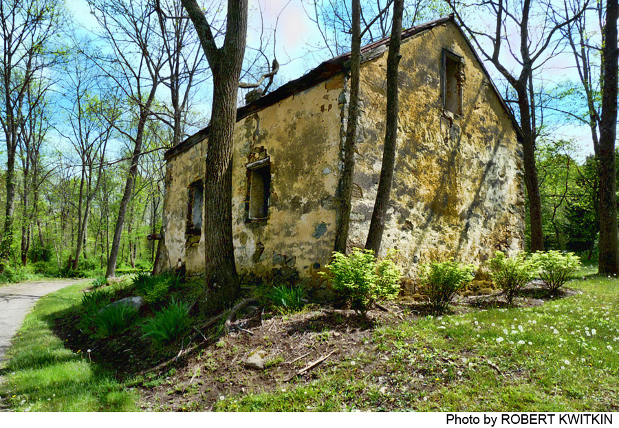
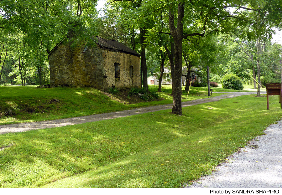
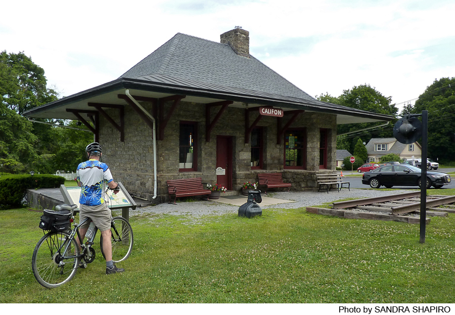
Crossing Main Street, the Trail follows Railroad Avenue, and passes an old railroad station converted into the Califon Museum with relics of the railroad’s bygone active days. The museum is open the first and third Sundays of the month from 1-3 p.m.
Parking is available across the street (Academy Road) from the museum.
Continuing west, the Trail heads through a residential area, paralleling Railroad Avenue for .75 mile. Just outside Califon, the Trail picks up the river again and runs parallel with it and River Road, and in .5 mile enters Lebanon Township through a forested section. The trail continues to follow the river after Hoffman Crossing Road, cut in places into the side of a slope with a steep embankment on the south side of the trail and a drop to the river on the north. The area is heavily wooded, the trail is shady, and there are great views of the rocky river below. The river is so clear that the rocky bottom is visible. One mile from Califon, the Trail enters the Ken Lockwood Gorge Wildlife Management Area, state-owned and managed for fishing and hunting.
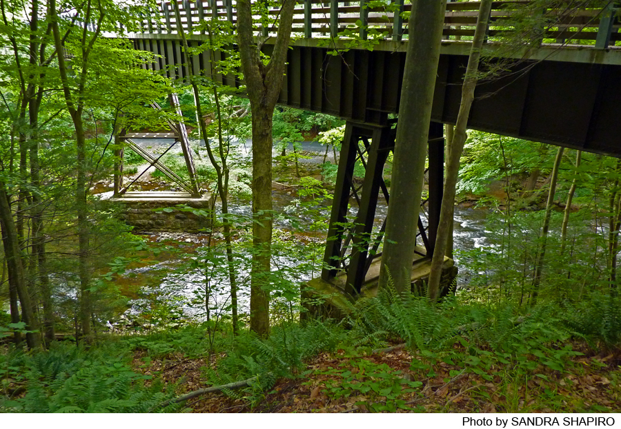
The Trail continues through this public preserve for nearly a mile, crossing a 290-foot concrete bridge over the Ken Lockwood Gorge, 80 feet over the river, with exceptional views. An historical marker tells of the April 1885 wreck of a train loaded with 40 freight cars carrying 500 tons of iron ore, five cars with 90 tons of pig iron, and one caboose. In 1891, a new steel bridge was built to replace the wooden bridge.
Parking of sorts is available on the southeast side of the bridge, where a steep path leads to a rocky road (Raritan River Road) that parallels the river. Under the bridge is a parking area with an information sign. It is a steep climb from the river to the trail corridor, making this parking area a difficult access for bicyclists and non-pedestrians.
The Highlands Trail, marked by teal diamond blazes, veers off the Columbia Trail in less than 1/4 mile from the historical marker at the bridge.
The Trail parallels the river on a slope above the bank. After the bridge, the Trail climbs, as trail users see glimpses of the water peek in and out on the river side; the other side of the Trail is a rocky slope. About 2 miles west of the bridge, the trail leaves Lebanon Township and enters Clinton Township. A bridge crosses Cokesbury Road and the surrounding countryside begins to show development, typically larger homes or estates.
At mile marker 6 traveling west (1 traveling east), the Trail enters High Bridge Borough. The river widens behind the dam creating Lake Solitude, a premier fishing lake open to the public for fishing. Waterbirds, bald eagles and pileated woodpeckers, have been sighted around the lake. Around the 6.5 mile marker going west (.5 mile post going east), there are informal trails to the dam and spillway. A metal fence marks these well-used, informal paths. Bikes are not recommended down these paths due to the steepness of the slope. The lake is not visible from the Columbia Trail.
After Lake Solitude, the Trail enters the village of High Bridge, crossing some streets and under others, on a surface that is now asphalt. The Trail ends at Main Street (Route 513) in High Bridge.
Across Main Street from the trailhead is a public park entitled High Bridge Commons. The park consists of ballfields, playground, and gazebo. High Bridge is a quaint downtown area offering restaurants, pizzerias, delis, and other places for refreshment.
Directions to western (High Bridge) trailhead: From the junction of Route 78 and Route 31 in Clinton, proceed north on Route 31 for 1.7 miles to Route 513 north. Turn right and follow Route 513 into High Bridge. After approximately 1 mile and passing under the train tracks, turn left into the center of High Bridge. Parking: Just before the Borough Hall, turn left onto Van Syckles Street. Public parking is available in the municipal parking lot.
-
Do you have information about this trail?
Click Here to contribute.
-
This is a great trail for learning about the rich history of this area. It passes through historic villages like Vernoy, Califon with its Museum, and Middle Valley, which was settled in the early 18th century by German farmers, and boasts about 40 historic buildings in the Italianate and Greek Revival style. The railbed along which the trail runs was used by the Central Railroad Company of New Jersey, which began in July 1876 to bring iron ore from the mines in Chester, Hacklebarney, Mine Hill, Wharton and Hibernia to the Taylor ironworks in High Bridge. These products also ended up in Bethlehem, Pennsylvania, foundries and steel mills. Half of the iron ore mined in New Jersey was transported on the High Bridge Branch. In addition, the railroad transported milk, lumber, ice from Lake Hopatcong, U.S. mail, quarry stone, coal, peaches and other agricultural products, sand, general merchandise and passengers. Children rode the train to High Bridge and Dover to attend school. The train transported 89,000 people annually from 1876 to 1932. Its last train ran in March 1976.
Do you have information about this trail?
Click Here to contribute.
-
Photos
Videos